

Plan a Point Reyes day around the lighthouse
A late-November itinerary for the western headlands, with time for the stairs, a shorter visit at the overlook and a fallback if wind changes the day.
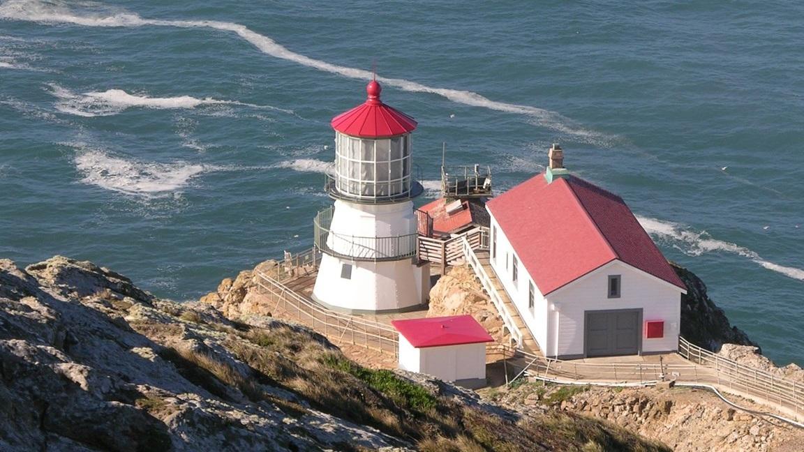
At the Point Reyes Lighthouse, there’s a place to stop before you commit to the stairs. From the observation deck you can look down at the red roof and the pale tower, where the headland falls away to the Pacific. The National Park Service puts the light station about 240 feet below the deck. Between the two are 313 steps. You can spend half a day in this part of Marin County and come away with a good trip having climbed none of them.
That’s worth knowing if you’re planning around Thanksgiving. The park’s published visitor-center schedule lists 10 a.m. to 2 p.m. for the lighthouse on November 26, two hours shorter than the usual end time. Staff close the stairs when winds exceed 40 miles an hour, and the park advises checking conditions before setting out. The better plan for a mixed group is to choose a time for the headlands, give everyone the same first stop, then see what the weather and the people you’re traveling with can comfortably do.
Start with the drive and the day’s alerts
Start the clock at Bear Valley Visitor Center near Olema. NPS estimates about 45 minutes by car from there to the lighthouse parking lot. The route follows Bear Valley Road to Sir Francis Drake Boulevard and then heads west across the peninsula. That’s the drive from the park’s main visitor center. If you’re leaving from elsewhere in the Bay Area, add the time it takes to reach Bear Valley in the first place. Keep the calculation separate so an hour in traffic on the way to Marin doesn’t quietly eat up the entire time you meant to have at the coast.
Look at the park’s current conditions page before you leave. It points to road and trail advisories, weather and tides, visitor-center details and wildlife restrictions. A gate on the way to the lighthouse changes what you can do more decisively than a few extra minutes on a maps app. Download the park map if you’re relying on a phone. Put water, a layer that can handle wind, and footwear with grip in the car while you’re still somewhere it’s easy to turn around. Bring a picnic or plan a meal in town if you expect to visit over the short holiday hours.
Give the lighthouse the earlier part of the day if it’s what brought you out. On Thanksgiving, a departure from Bear Valley at 9:45 a.m. would put you at the parking area at about 10:30 a.m. under the NPS driving estimate. That leaves time to walk up, stop for the view, make a decision about the stairs and return without building the plan around a 1:55 arrival. Treat the estimated arrival as an illustration. Road conditions, parking and the speed of the group can each add time.
Get to the deck before deciding about the stairs
From the main parking area, NPS describes a mostly uphill walk of about 0.45 mile to the lighthouse visitor center. On the way back you’ll cover the distance again. If someone in the group has a parking placard or plate, the park’s lighthouse page describes designated accessible parking beyond the service-road gate and gives directions for reaching it. Review those directions together before leaving. For an RV, trailer or other large vehicle, check the parking restrictions and options at Bear Valley. Turning up at the narrow end of the peninsula is a poor time to discover the lot was designed for a different vehicle.
The observation deck is the first place the park identifies for seeing the lighthouse from above. It’s a useful shared destination if your group spans a few levels of energy. Take time there to look at the position of the tower down the cliff. The site’s history and the water below make more sense once you can see the elevation change. If the visitor center is open, the park describes a picture window where you can look out at the coast from shelter. That’s a reasonable next stop when the wind makes a long time at the railing unpleasant.
If the stairway is open and you want to descend, budget for coming back up under your own power. Getting down can feel easy when the view is opening up ahead of you. The climb back is the half that determines how much energy you have for the rest of the afternoon. Take the pace that works for you, leave room on the stairs for other visitors and use the deck as the meeting spot if some people choose the climb and others don’t. Agree on a return time that allows the slower walker to stop and catch their breath.
A Tuesday visit has its own wrinkle. The lighthouse visitor-center schedule starts at noon on Tuesdays, when preservation work often occupies the morning. The observation deck has a longer daily access window in the park’s published hours, so the visit can still have a shape even if you arrive before the door and stairway open. On any day, treat the hour in the timetable as one condition. The wind threshold is another. Refresh the conditions page before driving out, and follow whatever staff have posted when you arrive.
Pick one more stop with the wind in mind
If the breeze is manageable and you have time for an exposed walk, consider Chimney Rock. The turnoff comes near the western end of Sir Francis Drake Boulevard. NPS describes the last 0.9 mile to the trailhead as a one-lane road and posts a vehicle-length restriction. The trail is 1.8 miles round trip and has views over Drakes Bay and the Pacific. The park estimates 40 to 60 minutes of walking to the end and back. Allow more time if you stop to watch the water. Dogs aren’t allowed on the trail.
At Chimney Rock, stay on the maintained route. NPS identifies parts of the peninsula where bluff erosion is especially active. The view doesn’t depend on getting to the lip of a cliff. A good place to turn around might be the point where you’ve seen the water on both sides and the walking has stopped being comfortable. Leave time to return in daylight, particularly if you’re taking a slow drive back through the headlands. If the lighthouse visit used the energy or time you had set aside for walking, choose an easier second stop.
Drakes Beach offers a different option farther back toward Bear Valley. The park lists about 30 minutes from Bear Valley to its parking area. Check beach access and postings before heading onto the sand. A section at the western end is closed year-round to protect the elephant seal colony, and seasonal restrictions beginning December 15 expand the closed area. Temporary restrictions can also change with the animals’ location. A beach stop can still work as a place to look across the bay or eat a packed lunch from a permitted spot. If the weather is rough, check for surf advisories and use a view you can reach without approaching the water.
Leave space for an early turn
When the headlands are under a road advisory or the wind makes them a bad fit for your group, change the destination before doing the full drive west. The Bear Valley area gives you a closer starting point for another plan. If conditions are suitable and the trails are open, the park’s hiking guide describes a 3.2-mile round trip to Divide Meadow, through wooded terrain with a different kind of shelter and scenery. A group that wanted a short visit can do an out-and-back segment that fits its daylight and energy. Check the visitor-center holiday hours separately if you want to go inside or ask a ranger about routes.
If you’re bringing a dog, decide on access as part of the route. NPS lists the rules by site and gives separate guidance for several beaches and trails. The lighthouse and Chimney Rock shouldn’t be treated as stops where the same permissions apply as a neighborhood park. Plan a destination where everyone in the car can get out and follow the rules, especially if a long drive would otherwise leave someone waiting with the dog. On a holiday, have that conversation before you’ve packed lunch and committed to a stop that will take an hour to reach.
A simple version of the day is to reach Bear Valley in the morning, drive out to the lighthouse, take the time you want at the observation deck and pick one afternoon stop on the way back. If the stairs are open and you have the legs, go down and back. If the wind closes them, you still have the view from above or a chance to spend the time closer to town. The part worth building in either way is a margin between arriving and needing to be somewhere else. The lighthouse looks better when nobody is checking the time halfway up the stairs.
Leave yourself a stop on the way back if your group wants something warm. A thermos works even if a shop has shortened holiday hours. If you’d rather buy lunch, check one place’s hours before leaving home and use that as a loose target. You’ll have a reason to start back before people are cold, tired and hungry at the far end of the peninsula.
Sources
- National Park Service lighthouse visitor guide and stair, parking and accessibility details
- National Park Service visitor-center schedules and 2026 holiday hours
- National Park Service current conditions, updated November 17
- National Park Service directions via Sir Francis Drake Boulevard
- National Park Service Chimney Rock trail guide
- National Park Service seasonal, wildlife and beach closures
- National Park Service hiking guide
The Point Reyes Lighthouse sits below the observation deck on the western headlands of Point Reyes National Seashore. Photo credit: National Park Service.